
The LA River is 50 miles long of, mostly, undeveloped land which touches 17 different municipalities. Many interested constituencies, for years, have hoped to take advantage of the potential opportunities of the waterway. In 1996, LA County developed its first master plan to address these opportunities. The plan, which was last updated in 2022, includes many goals, among them flood control, more parks and recreation, affordable housing and river access. VX News presents this excerpt from a ULI panel moderated by SOMOS founder Alfred Fraijo, featuring Mark Pestrella, the director of LA County Public Works, who updates the Plan’s buildout, the history of the waterway, civic engagement of stakeholders, governance issues, and the sheer amount of potential to be found along the LA River.
Alfred Fraijo: Mark [Pestrella], give us your perspective on what’s working and what may be some challenges...
Mark Pestrella: All these watersheds that were described, I [have been] figuring out just how they work, how they operate, who lives there, what the impact of our constructed environment has been on not just the community, but the wildlife.
It was a pleasure to begin my career in the Malibu and Santa Monica Mountains. People asked me what I do all day and I would tell them that I walk around the mountains and determine where people can build homes safely and without too much damage to the environment. It really was a wonderful job in which I actually got to go surfing during lunchtime. The land and water in Los Angeles County has been really important to me throughout my whole career and I think it comes from studying Civil Engineering and my family's background from Hawaii….
Our department has many business lines
We're organized in sanitation, we pick up a lot of trash and are the county's waste planner. On top of that, we operate three landfills. We are also a building official for the county, doing the review and entitlement process with separate entitlements for arginine development within the unincorporated areas. We're also,I think,16 cities’ contracted building officials,which makes me the building official for a lot of people. The other piece we're involved with is transportation-- converting and transforming Los Angeles’ transportation. Our interconnectivity to the metro system is quite significant and at the same time, we're maintaining traditional road systems and converting those into multimodal systems. Then, of course, we're the county's builder with about $4 billion operating our construction budget and no capital improvement budget. Right now we're in the midst of one of the largest projects in Los Angeles, rebuilding the Harbor UCLA campus medical campus, the third-largest public medical system in the United States. We're getting close to completion…
Then there's the love of my life, the flood control in the water system of Los Angeles County. The County’s Public Works Department houses the Los Angeles County flood control district and we’re also a water retailer. We’re the third largest water retailer in the county, serving something like 250,000 connections, mostly in Northern Los Angeles County. We also serve the most expensive imported water in Los Angeles to the Malibu area. A little interesting thing, we have about two days of water supply because we pump all that water up there in tanks.
The flood control district itself is one of the largest systems in the United States with the co-eco goals of water conservation and flood protection. I learned about the Flood Control Act, which is a state act serving as the board of the financial district. The act emphasizes avoiding being a blight on the community by resorting to the highest and best water use. These authorities have been really useful in recent years, keeping people safe, saving lives and property, and conserving and replenishing the waters in Los Angeles County through a system that we operate to capture a third of the drinking water supply annually. In fact, this year, we captured almost two-thirds of that water. 600,000 acre-feet of water were captured and replenished into groundwater basins as part of the greater Los Angeles Basin.
Then we get to the big dog, the LA River watershed, depicted on the screen here.

Yes, it's 51 miles long. The built channel took the place of a train system that ran across this vast aluminum swath. Here we have the San Gabriel Mountains, some of the oldest mountains along with the newest and youngest mountains in the United States that are growing at the fastest pace. They can reach as high as almost 10,000 feet, and we can have rainfall up to 36 inches in a rainstorm, but we can also have as little rainfall inDowntown LA at 10 inches per year.
It's quite a dramatic watershed; geologically, physically, topographically, and then it's really dynamic when looking at how it’s occupied and how that changes. There are so many cultures and so much biodiversity in just this one watershed alone. It's almost on a scale that we can't imagine.
I’ve brought people from all over the world, trying to describe this watershed to them, and it is almost too overwhelming to comprehend. There are about 3 to 4 million people at any given time living in the watershed. There’s great biodiversity. We have very famous mountain lions in this watershed, and everything down to burrowing owls and all kinds of snakes. We have fowl, waterfowl, as well as bird life-- it's incredible. We have waters that rush through it at an incredible speed, which could wash away anything in its path. There’s not much landform, so not much would be able to withstand given the velocities; we have velocities up to 20 feet per second for many sections of it. It goes up to as much as 160,000 cubic feet per second, and for those of you that aren't civil engineers, that's like 160,000 basketballs filled with water going by every second. It's a tremendous thing to mess with, and as you said at the beginning, it was audacious of us human beings to believe we could mess with it. In fact, the Army Corps of Engineers and the County of Los Angeles got together in the 1930s, after many devastating floods, in which this river system picked its path whenever there was a major flood flow event about every 7 to 10 years, changing directions multiple times.
It ended up going out via the creek to Santa Monica Bay at one point, then came back down to San Diego, back to Santa Ana, and back to San Diego. And this is why we have the delima we have—it was flowing towards San Diego, so we decided to line it.
People debate it all the time, but we lined the river because, as mentioned previously, the economy of Los Angeles was thriving in those early years. While we only had a couple of hundred thousand people living here, we had an economy that was taking off-- mostly agriculture. As LA was becoming more centric to Hollywood, there was still mostly agriculture, but also a great movement of goods that was occurring. The railroads were trying to make their way across these river systems, but it became very apparent that the movement of goods wasn't able to be consistently met. Controlling the series of river systems across this great stream in San Gabriel and Los Angeles could solve this issue. In those years of rain, the Los Angeles River was the Wild River. So this is what we're dealing with originally, not to forget about the ancestral lands that were mentioned previously.
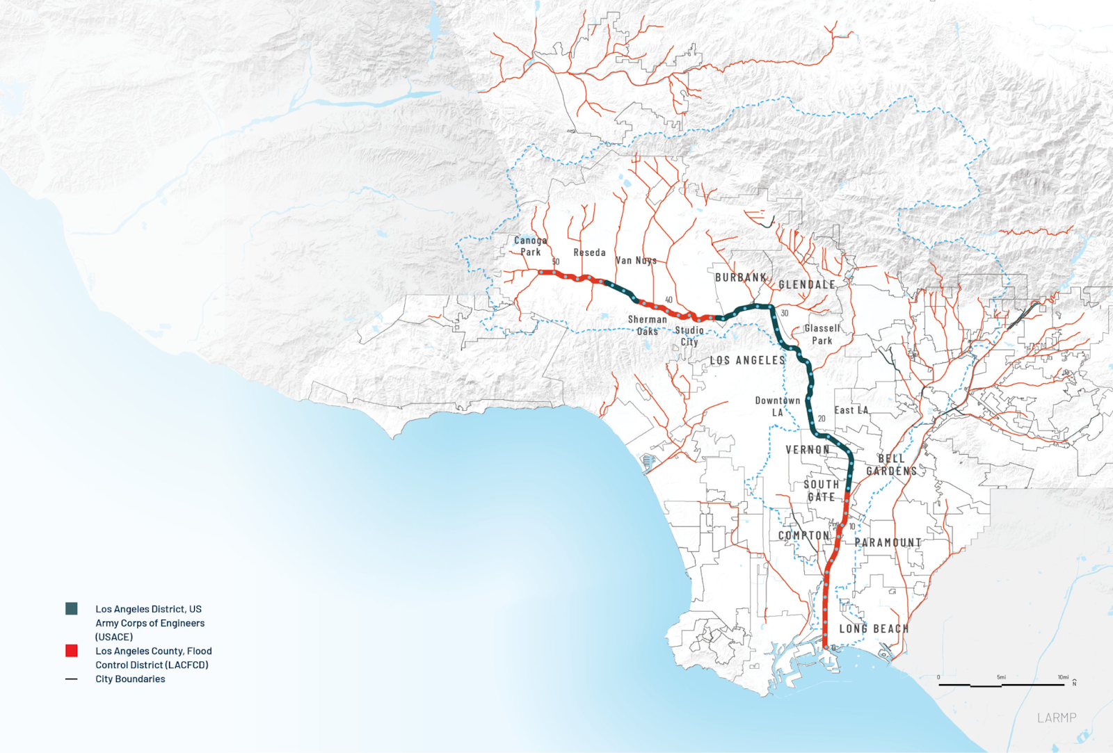
Right now, the river runs 51 miles from Canoga Park to Long Beach. It's 2,300 acres of primarily publicly-owned land, and at scale, it dwarfs Central Park in New York. If we green the entire area, we would have nearly 1 million people live within a mile of the river, and most of the LA county residents actually live within the river's watershed.
A third of California residents live within one hour of driving to this river, and people, for many years, didn't recognize that it was actually a river. In fact, we did build somewhat of a man-made river here, so it isn’t the configuration of a natural river state. You would see braided streams across this massive aluminum as it was coming from the very young mountains and continues to come down today; it’s probably the biggest erosion-producing, sediment-making machine anywhere in the United States.
The history of the river is amazing, and I can go on and on about it. You heard about the channelization of it earlier as a big mistake. The fact of the matter is that people were making decisions at a time based on the values of that time when they were living here. I always say for you ULI folks-- remember it's all about land use. The river would not have been converted if it wasn't for the demand on the land and its way to produce. Land use decisions in Los Angeles were made in such a crazy and scattered way because of the rush to develop Los Angeles.
So now, we’re dealing with really poor land planning, and I can say that from an expert's perspective; as a building official and land use person early on in my career. Those early land use decisions, as we’ve mentioned, really locked us into something that people are trying to unlock. That’s the vision of the LA River Master Plan-- to reflect the evolutionary values of Los Angeles as discussed earlier and to reflect the values of communities that are living alongside the river.
We took three years to develop the LA River Master Plan and conducted thousands of outreach efforts to hear from people. First, to understand before we seek to be understood. This was actually very joyful because we learned about the biases we had as planners, engineers, city officials, and all the stakeholders. In fact, many of the environmentalists who were partners for years learned much more about the vision of the community living along the river by taking the time to authentically communicate with a mindset of equity. We looked for those we hadn't heard from before, and interestingly enough, resulted in 51 mile-markers.
Recognizing the cultures were so diverse all the way up the river, we wanted a way to indicate what mile we were at, and more importantly, what culture we were actually talking to or engaging with. I’d say that there are more than 51 cultures going on a 51-mile, one-mile mark at a time, which was a scale we had to work out. It’s a massive opportunity to rethink and reimagine Los Angeles, and it’s been a blessing to be involved with developing a vision for our board supervisors who adopted this plan in 2020.
As mentioned, the plan was adopted but not without controversy. The narrative about the Engineer Corps in LA County destroying this beautiful riverine system that was perfectly lined with roses and grapes still existed. In fact, it was quite an interesting journey with heroic engineering to get it done. Decisions made along the way were thinking about how we can do it better. So what we are doing differently in the engineering, land use world, horizontal construction, and infrastructure world is different-- we're thinking about the systems we build as systems of systems, rather than siloed systems that are adjacent to one another.
Look at the transportation system with the LA River, the sewer system, and the systems of civic spaces around the river. As spoken on by the previous speaker, we are trying to look at this in an integrated fashion, integrating all of the inputs and the data. Especially the big data that we’ve had to process in expressing a multi-perspective vision. This required that 51-mile designation, and it required us to respect a lot of different voices. In fact, many of those voices believe they have the vision for the river. Whether it's those who want the river converted to green space, be opened up, and more riverine looking, versus those who have said the concrete should still stay in place.
Absolutely varying opinions but from an engineering perspective, I'm going to be asking if we can even take the concrete out and direct contributors to the plan. We looked closely at what that option would be, considering the impacts on people who live there, the gentrification that would occur if we did such a thing, the impact of the flooding, and the greater forces of climate change. We came to conclusions that were based on a lot of data, resulting in this complex system of systems thinking.
The last piece of this all is that it cannot be completed without money-- so let's just get down to it. The development community has, for some time, profited from the land use of Los Angeles County. They build for us, and I very much see them as partners. We have a great opportunity to work together and make a profit from what might happen through the execution of this vision, of what we're going to demand through regulation, cleaning, and provisioning, and through charitable giving with corporate entities.
It'll reflect the needs of not only the existing communities but the ones to come. My belief is that the children that come here won't even know where this came from-- it'll just be this way of life. Without even understanding why or what it was about, it just is this gathering place, this connection between communities. It’s an audacious vision and planning. I really encourage you to take a look at the adoptive plan to know more about the opportunities for the development community as well as our community at large to enjoy this incredible amenity here in Los Angeles County.
Alfred Fraijo (moderator): Was the creation of the joint powers authority (JPA) to aggregate the collective authority?
Mark Pestrella: Let me be very clear; the problem with natural resources and the management piece is this political watershed governance-- It's 100% always the problem. Getting people to agree on one vision to go in a single direction. In fact, the flooding in the district is already within three JPAs within the larger Los Angeles area, so sharing common goals with our jurisdictions and using our authorities together to push common interests for the LA River is pretty tough. We've had different approaches-- one of the reasons that the JPA is a problem is that the Corps of Engineers actually owns and operates a component of the river. Land ownership is a crazy thing if you’ve ever seen it.
On education/ Need for the civic engagement of young people (panel conversation)
Mark Pestrella (concluding panel remarks)
As you mentioned about education, there's another piece of this, just while we're educating people on the riverine system and the environment. I used to say that the people in LA don’t reach out to the environment-- the environment reaches out to them.
So people reach out to an environment with so many cultures, considering the racial tension in LA, and other social groups in LA-- the connections that we're making longitudinally and latitudinally are reflected in the design we're going to be doing. Some of the concepts include park-like features that bridge and connect communities across the river. It's very interesting that you can live on one side of the lower river and never know the other person right across. They're literally separated by 300 feet of river, and they would never know that because of the massive disconnect we created by putting this trench up, cutting off the communities. Full communities are separated by the river and it’s pretty sad. The faculty of education is allowing us to work on cultural issues like easing racial tension and raising awareness.